Posts

The days are starting to feel a little shorter, and the copper-hued afternoons of autumn loom just around the corner. You know you should be logging some mountain miles and soaking up the last leg of summer, but we get it—finding the motivation to run through soaring August temperatures is not easy. To help you get going, we’ve found five of the most refreshing trail runs in the Blue Ridge. Get ready to slosh through streams, run alongside the river, and quench your thirst for summer adventure while you still can.

1. Warren Wilson College River Trail

The peaceful, pastoral campus of Warren Wilson College in Swannanoa, North Carolina, is home to one of the most charming trails in Buncombe County. Carved into the banks of the Swannanoa River, the River Trail is a flat, 5 mile out-and-back ramble through idyllic countryside. The gentle current and clear water flowing beside you will prove tempting in these last dry weeks of summer, and there are plenty of pebbly shoals and deeper pools to take a post-run dip.The varied terrain of the River Trail includes working farmland, swathes of pastel meadows, shaded forest and even a small bamboo grove. The path is foot traffic only, and you’re likely to encounter a handful of fellow runners and barefoot college students out for a stroll between classes. Dogs are welcome but must be kept leashed at all times, a policy that is strictly enforced. Trailhead is located at Charles D. Owen Park, 875 Warren Wilson Road in Swannanoa, NC. 

2. Vineyard Gap and Riverside Trail

For more experienced runners, the Vineyard Gap Trail in Pisgah National Forest climbs 2.3 miles up and over Forge Mountain, then descends into the South Fork of Mills River. Here you will meet up with the Riverside Trail, which will eventually loop back to the parking lot, totaling 7.4 miles of sweet mountain running. As always in Pisgah, roots, rocks and ruts will keep you on your toes, but the remote landscape and cool, quiet forest make for a pleasant and absorbing experience. The trail crosses the river several times, and these invigorating interludes will cool you down and keep you running strong. The water is knee-deep at times, so be mindful of slippery rocks and river levels, and do not attempt to cross at high water.

Access from the Turkeypen Gap Trailhead Parking area on Turkeypen Road (FS 297).

3. Reasonover Creek Trail to Lake Julia

Lake Julia awaits at the end of the Reasoner Creek Trail.
Melina Coogan

This beautiful singletrack trail rises and falls over moderate hills for 3.27 miles, all within the shade of a dense hardwood canopy. Toward the beginning of your run, make your way carefully across a wide creek by hopping across twelve neatly positioned rocks, or wade through the shin-deep water for an initial cool down. You will splash across the creek a few more times before getting your first glimpse of Lake Julia, smooth as glass and glinting through the trees. Although accessible by forest roads, Lake Julia is remote enough that it remains relatively quiet and calm, a novelty for most DuPont swimming spots. You may share the lake with other runners, mountain bikers, and stand up paddlers, but there is generally a corner of solitude to be claimed. When you’re ready to turn for home, head back on the same, scenic trail that you came in on. As always in DuPont, be on the lookout for bikers.

Park at the Fawn Lake Access area on Reasonover Road. On foot, turn right after the gate for 0.1 miles. The trailhead is located at the intersection of Conservation Road.

4. Stone Mountain Falls

The view from Stone Mountain.
bobistraveling

Nothing epitomizes the beauty and grandeur of the Blue Ridge Mountains like a waterfall, and nothing could be a more welcome and refreshing site at the culmination of a hot summer’s run. The Stone Mountain Loop trail in Stone Mountain State Park is a super fun, 4.5-mile adventure that will lead you to a 200-foot granite monolith of cascading water on Big Sandy Creek. Explore the pool at the base and exult in the mist before tackling the man-made staircase that climbs the east slope of the Mountain to the top of the falls.

Stone Mountain State Park in Roaring Gap, NC, spans across Wilkes and Alleghany counties. Access the trail at the park’s lower trailhead, 2.5 miles down the road from the visitor center.

5. Bent Creek Trail

Azaleas in bloom alongside the Bent Creek Trail.
Erin Brierley

This is a perfect option for beginners, or anyone looking to sneak in a run before work. Bent Creek trail meanders on even ground for 1.3 miles through the North Carolina Arboretum , alongside the diamond clear waters of its namesake creek. It even passes through a portion of the National Native Azalea Repository, making for a brief but stunning loop that is guaranteed to make your short-list. The trail parallels Bent Creek Road, where you will find several intersecting trail and road options to explore beyond the Arboretum and the adjacent Pisgah National Forest.

JOIN OUR NEWSLETTER

Originally written by RootsRated.

Featured image provided by Julia Pethtel

Intro

Mt. Pisgah Campground is located high atop the Pisgah Ledge at Flat Laurel Gap off of the Blue Ridge Parkway. Centered amongst the wonders of the Pisgah National Forest, at an elevation of 5,000’, the Mt. Pisgah campground is ideally located for a ridgeline retreat. This mountain top campground is home to 70 tent and 70 RV sites, restroom and shower facilities, as well as several handicap accessible sites. Pack up all the luxuries car camping affords and reserve a spot in the heavenly confines of Mt. Pisgah Campground for your next adventure vacation!

What Makes It Great

The true beauty of this campground lies in its unique location along the Blue Ridge Parkway. A 20 mile drive along the scenic Blue Ridge Parkway takes visitors high atop the prominent Pisgah Ledge on its way from Asheville to the Mt. Pisgah campground. The campground is nestled amongst some of the finest outdoor recreational opportunities around. With little more than a short drive campers have access to the Big East Fork and Black Balsam trailheads, Mt. Pisgah, Looking Glass and Sliding Rock as well as the famous mountain biking trails of the Pisgah National Forest! An elevation of 5,000’ ensure cool summertime temperatures! The campground also has access to a picnic area and nature trails that leave directly from the grounds.

The world famous Pisgah Inn sits directly across the parkway and gives visitors unique access to the finer things in life as they camp in the wilderness. The dining room at the Pisgah Inn is lined with glass and overlooks the pristine Pisgah National Forest below. A delicious array of Breakfast, Lunch and Dinner items are served to patrons as they enjoy the finest view available from a dining room table! The Pisgah Inn also offers a Country Store, for those last minute camping supplies, and access to laundry facilities to refresh your wardrobe on prolonged outings.

Who is Going to Love It

The Mt. Pisgah campground and its surroundings amenities combine to form an outdoor oasis that “glamping” dreams are made of! Take advantage of the drive-up campsites by bringing your luxury list of camping items! Venture out on an epic Pisgah adventure during the day then return to camp for a shower. Next, cap off your epic day with a beverage and the delicious fare at the neighboring Pisgah Inn; camping never tasted so good.

Directions, Parking, & Regulations

The Mt. Pisgah Campground is located at milepost 408 on the Blue Ridge Parkway. Gather your gear at Diamond Brand Outdoors, conveniently located right beside the Parkway!

Sites range from $16-$19 and the campground is open spring through fall.

Check Recreation.gov for more details on availability and reservations. For more information on the campground’s rules and regulations and a detailed map of the grounds click here.

JOIN OUR NEWSLETTER

Featured image provided by Steven Reinhold

Intro

One of the closest hikes to Asheville with the best long-range views is Craggy Gardens at Milemarker 364.1 off the Blue Ridge Parkway. Because of its easy access, this is a popular spot and although its never exactly ‘crowded,’ you won’t be alone during the summer or fall. Come at sunset for unobstructed views over the Black Mountains.

Craggy Gardens is the go-to spot for a quick weekend hike that’s accessible and generally pretty easy, if a bit steep. But it’s only a 1.4-mile loop, so it’s a moderate hike even for families with children.

What Makes It Great

If you’re coming from downtown Asheville, the first thing you’ll notice is that the temperature here is usually at least 5 degrees cooler than it is at lower elevations (and sometimes as much as 20 degrees cooler), so be prepared and bring warm clothing, even if its summer. There’s a slight lag in the seasons at this elevation, too, so you may not see leaves on the trees until May.

The Craggy trail is carved through a rhododendron thicket, so its especially beautiful around mid-June when the flowers are in bloom. The trail is a little steep, but shouldn’t prove too challenging even for children. There are several overlook spots along the trail.

In the summer, slabs of slate gray rock and bright pink rhododendron blooms create a vivid landscape, surrounded by panoramic 360 views of Asheville, Mt. Mitchell, and the endlessly undulating Blue Ridge Mountains.

Who is Going to Love It

This is a great starter trail for kids: quick, steep without being overly demanding, with a dramatic mountain top finale that’s perfect for picnics. This hike could be combined with other attractions on the Blue Ridge Parkway such as Graveyard Fields and Skinny Dip Falls for a full day of warm weather exploration.

Directions, Parking, & Regulations

Located on the Blue Ridge Parkway only about 30 minutes from downtown Asheville, the Craggy Gardens Trail starts at the Craggy Pinnacle parking lot at milemarker 364.1 (just beyond the Craggy Gardens Visitor Center at 364.6).

JOIN OUR NEWSLETTER

Featured image provided by Selena N. B. H.

Your opportunity to experience a rare total solar eclipse in western North Carolina arrives on Monday, August 21. To make sure you’re prepared and packed for totality, the experts at Diamond Brand Outdoors have assembled this helpful checklist. For more on what to expect, check out Everything You Need to Know About August’s Total Solar Eclipse.

Click here for a printer-friendly PDF version of this checklist.

What to Do Now for the Total Solar Eclipse

  • Select the best location and route for viewing the eclipse based on accessibility, weather forecast, and the time of day the path of totality will pass through the area. Many prime viewing spots require tickets or have a capacity cap in place for the day, so do your homework.
  • Select an alternate location and route. 64,000 tourists are expected to visit the mountains for the eclipse.
  • Book lodging close to your primary viewing location. Hotel rooms, campsites, and cabins are going fast!
  • Build your total solar eclipse viewing kit. (See the bottom of this post for a checklist.)
  • Purchase your eclipse viewing glasses at Diamond Brand Outdoors. We’ve ordered a lot, but they’re going fast!
  • Use an app, website, or book to find out which bright stars and planets you can expect to see during the totality, impressing your friends and kids!

What to Do the Week of the Total Solar Eclipse

  • Test all of your equipment by doing a “dry run.” Nothing’s worse than having a faulty camera when the big event gets underway!
  • Pack your total solar eclipse viewing kit and camping kit.
  • Review the eclipse timing and weather forecasts for your primary and alternate viewing locations.

What to Do the Day of the Total Solar Eclipse

  • Check the weather forecast.
  • Leave early for your viewing location.
  • Claim your spot by setting up chairs and viewing equipment, but remember to be a good neighbor so others may enjoy the experience.
  • Test your equipment.
  • Enjoy the day with your friends and family. The time of totality will be brief, but the experience leading up and following the first total solar eclipse in western North Carolina since 1506 will lead to storied memories for years to come.

Total Solar Eclipse Viewing Kit Checklist

  • WNC + NATIONAL PARK MAPS: Cell towers will likely be overloaded, so don’t rely on an app.
  • ECLIPSE VIEWING GLASSES: You must have these for direct solar viewing.
  • HAT: To protect your head from the sun while you wait for the main event.
  • SUNGLASSES: NOT to look at the sun, but to cut down on the glare when you’re looking everywhere else.
  • PORTABLE PHONE CHARGER: Make sure you’ll be able to document the day through photos and videos.
  • CAMPING CHAIRS + TABLES: Get yourself a chance to stake your claim to watch and rest after the excitement!
  • BLANKETS: No matter where you’re watching, blankets keep things cleaner. Bring more than you think you need.
  • COOLER: You’ll likely get to your viewing area hours before the eclipse. Drinks, lunch, and snacks are a must!
  • DRINKWARE + WATER BOTTLES: Insulated cups and tumblers keep your drinks cold (or hot), don’t sweat, and are reusable.
  • HEADLAMP OR FLASHLIGHT: Since you’ll be looking up, this is primarily for emergencies. Use the red setting instead of white.
  • COMPASS: There’s plenty of information online that will tell you exactly where to look as totality begins.
  • CAMERA: This is one of the times you may want a nicer camera than you’ll find on your phone.
  • CELL PHONE: Coverage may be too spotty for weather and GPS, but your clock and camera will still work.
  • WATER: Always stay hydrated, whether the sun is shining or not.
  • SUNSCREEN: Always a good idea when you’ll be outside for any period of time.
  • INSECT REPELLENT: Another good idea anytime you’re heading into the outdoors.
  • OUTDOOR GAMES: Help pass the time and enjoy some relaxation with friends and family.
  • HAMMOCK: If you’ve got space to set up an ENO hammock or WindPouch, laying down is a great way to watch.
  • ELECTRICAL TAPE: Some folks don’t know how to turn off their camera’s flash. Be prepared to help them out.
  • CAMPING KIT (OPTIONAL): Traveling the day before or staying overnight after the eclipse helps avoid traffic and can be fun!
    • TENT
    • SLEEPING BAG FOR EACH CAMPER
    • LANTERN
    • SLEEPING PAD FOR EACH CAMPER
    • PILLOWS
    • TARPS
    • STOVE + FUEL
    • MATCHES
    • FRYING PAN + POT
    • CUTTING BOARD + KNIFE
    • SPONGE, SOAP, + BIN FOR WASHING DISHES
    • PAPER TOWELS
    • FIREWOOD (IF ALLOWED)
    • ROASTING STICKS FOR S’MORES + HOT DOGS
    • BEAR KEG
    • ICE
    • TRASH BAGS
    • FIRST AID KIT
    • CORKSCREW

JOIN OUR NEWSLETTER

Are you ready for the Great American Total Solar Eclipse? It’s rapidly approaching, hitting us full force this coming August 21. Millions of people will be traveling to see the moon cover the sun and all the crazy extras that go along with the phenomenon. The last total solar eclipse crossed the mainland states in 1979, so make sure you get out to see this one, because the next one won’t happen until 2024. Here’s our unofficial guide to everything you need to know.

The Solar Science

The paths of 21st Century North American eclipses.  Michael Zeiler, www.GreatAmericanEclipse.com

It sounds like sci-fi, right? “OK guys, one day in the future, the moon is going to completely blot out the sun. Day will turn into night! Stars will shine brighter than the sun! It’s going to be epic!”

So, sci-fi guy is right, but there’s some real science behind the eclipse. This is the time, celestially, when the Earth, moon, and sun are all in line together. The moon will rotate on its path around Earth and pass directly through the middle of our visual path to the sun. In this short period of time, the moon will completely cover the sun—at which point you will look up to see quite the spectacle. Day will have turned into twilight and the sun’s wispy atmosphere will extend around the moon. You’ll see stars in the daytime and colors streaking across the sky. That’s at full coverage. At partial coverage, the sky won’t darken much—but you will be able to get a clearer view of Venus.

Geometry plays an important role in this solar eclipse, too. The moon is about 239 thousand miles away from us here on Earth—which is oddly exactly the right distance to make it look the same size as the (much bigger and much farther away) sun, allowing it to completely cover the light during the eclipse.

Where to Catch a Glimpse

Gearing up to a seriously special celestial event—a time, when the Earth, moon, and sun are all in line together.  Thomas Lok

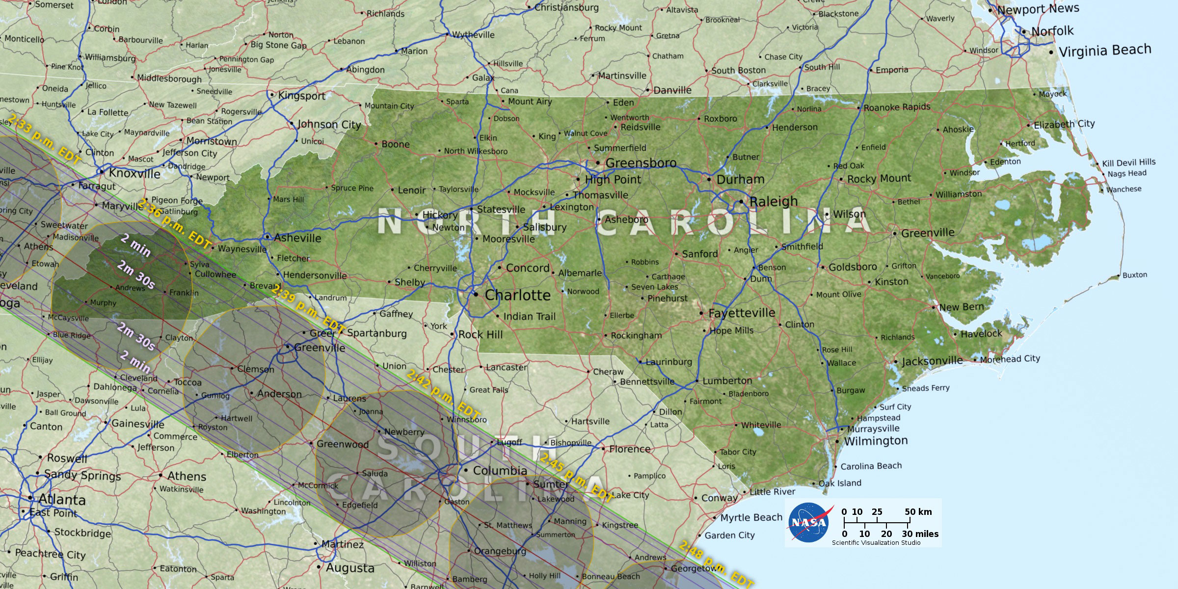
If you’re in the US, you’re lucky—you’ll be able to see anywhere from a total eclipse to 48 percent coverage. The path of totality (where you can see the sun completely covered by the moon) is a much smaller range, though. It goes through only 12 states: Oregon, Idaho, Wyoming, Nebraska, Kansas, Missouri, Illinois, Kentucky, Tennessee, Georgia, North Carolina, and South Carolina. And the totality viewing in those states is limited to very specific 70-mile-wide sections.

NASA has put together a selection of interactive maps allowing you to zoom in on the exact spot you should head to if you want to see the whole shebang. Totality only lasts 2 minutes and 40 seconds at the max with this eclipse, and it’s predicted to be a massive traffic day full of people trying to get to that center line. So go early.

This chart, compiled by Space.com and NASA, outlines totality times in the best cities to see the eclipse, all in local time:

Totality times for each state in the best cities to see the eclipse. Data from NASA

Where to watch in North Carolina

Asheville’s got plenty of viewing parties planned for spots like Pack Square Park and UNC Asheville, but you’ll only get to see the path of totality if you head further west. Tickets for viewing at Clingmans Dome have already sold out and certain areas of Great Smoky Mountains National Park will be closed on August 21. However, if you can turn the once-in-a-lifetime viewing into a weekend, some campsites and hotel rooms may still be available near Sylva, Brevard, Cherokee, or Murphy. Romantic Asheville has rounded up a comprehensive list of spots to watch the eclipse in the mountains.

2017 solar eclipse racing over Great Smoky Mountains National Park from Michael Zeiler on Vimeo.

Tips to See the Best Show

August 21, 2017 is predicted to be one of the most highly-trafficked days ever, as millions of people will be traveling to the path of totality.  NASA HQ PHOTO

Two words: eye protection. This is the most important tip we can give you for viewing the eclipse. Don’t go thinking you’re going to look straight at the sun—even if it’s partially obscured by the moon—and come away unscathed. You could burn your retinas to tiny eyeball-shaped ash piles. You could go partially blind. In short: you’ll damage the heck out of your peepers.

The sad reality is that the majority of the country will be out of the narrow path of totality the eclipse takes. It’s only 70 miles wide stretching from Oregon to South Carolina. The only people who can look at the full eclipse unencumbered by equipment are those in the path of totality. Most of us won’t see the sun completely covered by the moon, so we’ll definitely need eye protection of some sort. According to NASA, that means “special-purpose solar filters” like eclipse glasses. Sunglasses or homemade filters won’t work. Apparently only four companies make the glasses to international standards: Rainbow Symphony, American Paper Optics, Thousand Oaks Optical, and TSE 17.

Another option? Pinhole projectors. But you won’t be able to look directly at the sun—it’s an indirect method of viewing. Sky and Telescope suggests this process: “Poke a small hole in an index card with a pencil point, face it toward the Sun, and hold a second card three or four feet behind it in its shadow. The hole will project a small image of the Sun’s disk onto the lower card. This image will go through all the phases of the eclipse, just as the real Sun does.”

Of course, if you’re super fancy you can just use a properly filtered telescope.

JOIN OUR NEWSLETTER

Originally written by RootsRated.

Chilly days, chillier nights and rain showers may deter you from planning a camping trip, but there’s no reason to stay at home. Whether you’re visiting from out of town or a local just looking to change up the scenery, a host of cozy cabins, charming cottages, and even yurts can help you create that perfect weekend in the wilderness. Spend the night in a restored barn on a working farm, in a rustic cabin on a private island, or relaxing on the side of a mountain with a view of the city spread out below you. Here are five places to get away from it all.

1. East Fork Farm Cottages

The Mill House is a small and creative two-story cabin complete with a working waterwheel.
Courtesy of East Fork Farm Cottages

Imagine yourself rising early, surrounded by farmland, mist rising off the pastures as you sip a cup of hot coffee out on the deck. As the sky brightens, you consider the day that lies ahead of you: Maybe you’ll take a hike up to nearby Max Patch, a rolling meadow that many consider to be the most beautiful section in all the 2,168 miles of the Appalachian Trail. Or perhaps you’ll find yourself navigating the bouncy, Class III rapids on Section 9 of the French Broad River. In the evening, you will return to your cabin for a soak the fragrant, Japanese-style cedar hot tub and an excellent night’s sleep, submerged in the quiet of the countryside.

This will be your experience when you steal away to East Fork Farm for a couple days to unwind and recharge. The farm is family-owned and fully operational, located in the small mountain town of Marshall, NC, 25 miles outside of Asheville. There are three cottages on the premises: Meadow Branch is a quaint, cedar-shake getaway that is artfully furnished, with a view of the entire farm visible from the patio. The East Fork, cozy but modern, is an elegantly refurbished utility barn surrounded on three sides by meadows and grazing sheep. The uniquely charming Mill House is brand new addition to the farm, a small and creative two-story cabin complete with a working waterwheel and spacious patio.

As if pastoral serenity and quick access to wilderness isn’t enough, your stay at East Fork Farm will include complimentary farm products:  fresh eggs, stone-ground cornmeal, Highlander Farm jelly, Wild Mountain Apiaries honey, 4 ounces of Biltmore Coffee Traders coffee, and locally made soap.

2. Riverside Escapes

Enjoy an escape on the only private island on the French Broad River.
Courtesy of Riverside Escapes

Book a stay at the Riverside Escapes  and you won’t just be reserving a private cabin for the weekend, you’ll be reserving your own island. The rustic Americana Cabin is situated on the only privately owned island on the French Broad River , accessible by a 100-foot swinging bridge. Return to the simple delights in life by stepping off the river into an outdoor shower, cooking dinner over an open fire, and falling asleep inside a clean cabin, warmed by the glow of a wood stove.

If you’re looking for something a bit more plush, a brand-new cabin directly overlooking the river features the Riverview Retreat on the first floor and Treetop Suite on the second. Each luxe hideout features private hot tubs, a fully stocked kitchen, and a washer/dryer, nestled in 3 acres of wooded property.

The cabins are located in Alexander, just 20 minutes outside downtown Asheville. This would be the ideal getaway for anyone seeking to spend a calming weekend on the water, SUPing, fishing, floating, or just kicking back with a beer on the front porch.

3. The Pines Cottages

The Pines Cottages are close to fun nightlife, but still isolated for privacy.
Courtesy of The Pines Cottages

Stand in Pack Square on a Friday night and you’ll find yourself encompassed by small city revelry: The line from the French Broad Chocolate Company winds around the block, a string band plays boisterous bluegrass on the street corner, and tourists, college kids, artists, river guides and young professionals dart between breweries and file into the Orange Peel to catch a show.

It’s hard to believe that from such a crowded and lively vantage point, a place as quiet and tranquil as The Pines Cottages lies only six miles away. These vintage cabins and studio cottages sit on 4.5 acres of enormous pines and tidy gardens, tucked away from the hustle and bustle of Asheville, but close enough to take full advantage of the city’s nightlife and renowned culinary and craft-beer scene. Six of cottages feature wood burning fireplaces, and all of them are pet friendly.

Board games are available for checkout, as are guide books if you’re hoping to venture into the Blue Ridge Mountains and hop on some of the country’s most beautiful hiking trails.

4. Bittersweet Cottage and Suite

This expertly designed cottage and suite on Elk Mountain is a great home base for exploring Asheville.
Courtesy of Bittersweet Cottage and Suite

Perched on the slopes of Elk Mountain, the Bittersweet Cottage and Suite make for an ideal romantic retreat. The cottage features a cozy and inviting interior, with warm light, custom wood paneling and a glass block bath. The suite was designed with an Asian influence, soothing and clean with a fully stocked luxury kitchen. This modern mountain oasis is truly out of the ordinary. Both cottage and suite are impeccably decorated and offer an unparalleled view of city lights sparkling between rolling Appalachian peaks.

In fact, such a dazzling view might inspire you to spend the whole weekend wandering through town, immersing yourself in Asheville’s abundance of art and culture.  If that’s the case, check out these in-town adventures. Work up an appetite and get a taste of the outdoor activities for which Asheville is famous, without even leaving the city limits.

5. Wildwater Yurt Village at Nantahala

Luxurious simplicity inside the Yurt.
Courtesy of the Nantahala Yurt Village

Within the steep canyon walls of the Nantahala Gorge lie some of the most wild and pristine wilderness in the south. Whether you’re riding the ribbony trails at Tsali , zip-lining through the canopy or whitewater rafting with the Nantahala Outdoor Center , you will never exhaust the opportunities for exploration and adventure found here.

For an experience that’s off the beaten path—but directly on the hiking trails—reserve one of the eight coveted Yurts at Wildwater Village. These elegant domed structures of insulated canvas and exposed framing are where rugged meets boutique, creating a unique experience that will appeal to campers and  hotel aficionados alike. The yurts come complete with a queen bed, folding double futon, mini fridge, ceiling fan and space heater. Communal charcoal grills and a separate bathhouse with four private bathrooms (including private showers and sinks) are just down the path.

The Nantahala Yurts sit on the banks of two small ponds and above Lake Fontana.
Courtesy of the Nantahala Yurt Village

The Yurt Village is perched above Lake Fontana on 22 acres of mountain wilderness. Hiking trails wind from the property into the Nantahala Forest, a robust half a million acres of hardwoods studded with waterfalls and scenic overlooks atop exposed cliffs. With all that wildness at your fingertips, coupled with the plush comforts of the yurts, you may find yourself booking next year’s retreat to the Nantahala before you even pack up.

JOIN OUR NEWSLETTER

Originally written by RootsRated.

Featured image provided by Courtesy of East Fork Farm

It’s hard to deny the lure of mountain fire towers, with their place in history as guardians of the forest, and the intrigue of the solitary, beatnik existence of the watchmen who were once posted within them. Like lighthouses, these imposing structures still hold a certain element of mystery and nostalgia, and nowhere can you find a more spectacular view of the many mountain ranges that make up the Southern Appalachians. Here, five fire towers to explore in Western Carolina.

1. Shuckstack Firetower

Western Great Smoky Mountains

Looking out Shuckstack Fire Tower in the Great Smoky Mountains National Park.
Photo by Zachary Andrews

Standing at the top of Shuckstack Lookout Tower is easily one of the most dramatic and alluring experiences that you’ll find on any mountaintop in the Southeast. Sixty feet in the air, swaying gently but perceivably in the wind, you feel as if you’re standing inside a fixed mountain gondola. Through wraparound picture windows, you can spot the deep blue waters of Fontana Lake nestled inside the Smokies, as well as the full breadth of the Unicoi, Nantahala, and Blue Ridge Mountains.

Shuckstack Tower is located on a spur that juts off of the Appalachian Trail. The hike ascends a total of 2,100 feet in 3.5 miles, with the bulk of the steep terrain covered in the first 2.4 miles. After that, the trail evens out for an enjoyable mile, before turning sharply upwards again for the final scramble.

Take caution as you make your way to the top, as the tower has fallen into disrepair. A couple of broken steps and a section of missing railing are precarious illustrations of how the modern era has abandoned these dignified structures. Shuckstack is one of only three fire towers still standing in the Great Smoky Mountains National Park. When they eventually succumb to weather and age, there will be no way for visitors to climb straight into the sky, and the views from the top will belong once again to the birds.

2. Greenknob Lookout Tower

Northern North Carolina Blue Ridge Crest 

Looking down from Green Knob Lookout Tower.
Photo by Michael Sprague

The Green Knob Lookout is a quick dash from milepost 350.5 on the Blue Ridge Parkway, just north of Mt. Mitchell State Park . The half-mile trail is overgrown and nearly hidden, which saves it from the crowds that often gather at notable points along the Parkway. If you’re looking for a more substantial hike, begin at the Black Mountain Campground. From here, the trail totals 6.6 miles out and back.

Built by the USFS in 1931, the Green Knob Lookout is included in the National Register of Historic Places. It is located along the Eastern Continental Divide, perched atop the 5,080 foot summit of Green Knob Mountain. On a clear day, the tower affords breathtaking views of the Black and Great Craggy mountain ranges and the Piedmont of North Carolina, with the distinguished profiles of Table Rock and Grandfather Mountains rising in the distance. Due to its height and convenient proximity to the parking area, Green Knob is a fantastic spot to catch a sunset.

3. Mt. Cammerer

Eastern Great Smoky Mountains

The majestic Cammerer Lodge.
Photo by McDowell Crrok

It’s a burly 5.5 miles to reach the octagonal lookout tower on the summit of Mt. Cammerer , a mountain that straddles the state line of Tennessee and North Carolina. Your journey begins with three miles of steep switchbacks on the Low Gap Trail, ascending 2,000 feet before intersecting with the Appalachian Trail. The terrain then levels out along a scenic ridge line, with tantalizing views of the Cosby Creek and Toms Creek Valleys to keep you motivated. The final leg involves a scramble up a rocky spur as you approach Mt. Cammerer’s rugged summit.

This particular tower was constructed in the Western style, meaning that instead of rising above the trees on wooden stilts, the cab sits on a sturdy foundation of massive, hand-cut stone. Until the 1960s, rangers inhabited the tower in two week shifts from October and December, and again from February till May. It must have been a peaceful existence for the watchmen, observing autumn descend and spring bloom over the Pigeon River Gorge.

You can claim a few moments of tranquility for yourself inside the glassed-in cabin, with a panoramic view that includes Snowbird Mountain, the tower-topped summit of Mt. Sterling, and the Great Smoky Mountains unfurling in the Southwest.

4. Wayah Bald

Nantahala Mountains

Dramatic views from Wayah Bald.
Photo by US Forest Service – Southern Region

Until 1945, watchmen would inhabit the old stone lookout on Wayah Bald for two months at a time, sleeping in narrow, drop-down beds fixed to the wall and cooking over a wood stove. Their regiment involved walking the second-story wooden catwalk that surrounded their sparse dwelling, searching day and night for the flicker of flames or the dark halo of smoke rising above the mountains.

Of course, the human history of this area dates back long before the tower’s construction in 1937. Waya is the Cherokee word for wolf. Red wolves used to roam across the mountain’s bald summit, and spear points dating back longer than 11,000 years have been discovered scattered in the ground.

Today, the upper stories have been removed, and the stone structure that remains looks like something that was lifted from a mediaeval landscape and dropped in the Southern Appalachians. A wrap-around staircase descends from the top of the tower to a wide stone patio, providing panoramic mountain views that span all the way into Georgia. It’s not unusual to see a bride and groom gleefully posing for photos on the patio, taking advantage of this spectacular vista.

Wayah Bald rises 5,342 feet out of the Nantahala National Forest, just outside of Franklin, NC. The tower is accessible via the Appalachian Trail and the Bartram Trail, which stretches for 115 miles between North Georgia and Cheoah Bald in North Carolina. You can park very near to the trail for a quick jaunt to the summit, or begin at Wilson Lick Ranger’s Station for a lovely 3 mile hike on the AT.

5. Fryingpan Mountain Lookout Tower

Great Balsam Mountains

At 70 feet tall, the Fryingpan Mountain Lookout Tower holds the distinction of tallest USFS lookout in Western North Carolina. The summit of Fryingpan rises high in the Great Balsam Range, topping out at 5,340 feet. As one might imagine, the view from this combined height is unparalleled—so far reaching, in fact, that the tower was actively used for fire detection well into the 1990s!

The top tower is locked, but five flights of steel stairs will bring you just below the platform where you can savor the spectacular vista. The mountains in the distance, including Cold Mountain and Mt. Pisgah to the North, feel right up close and personal. The Great Smoky Mountain National Park and the Shining Rock Wilderness are also visible to the North and Southwest, an incredible payoff for a quick and easy hike (1.5 mile round-trip) on a gravel road.

JOIN OUR NEWSLETTER

Originally written by RootsRated.

Featured image provided by Andrew Piazza

Filled with sylvan streams winding through vast swathes of contiguous wilderness and crowned by the cloud-swaddled peaks of the southern Appalachians, Jackson County, North Carolina, is awash with natural wonders. Beyond the stunning backdrop, the mountain-nestled county is also peppered with inviting towns loaded with bountiful farmers markets, inventive craft breweries, farm-to-fork eateries, and boutiques showcasing locally produced artisanal crafts. Adventures are abundant in Jackson County, but here’s a shortlist of recommendations for an idyllic weekend escape.

Saturday

Photo by Nick Breedlove

Get a caffeine-injected start to your Jackson County adventure with locally roasted coffee and a portable bite from the Sylva Convenient Market and General Store in downtown Sylva. Stretch your legs walking the town’s main drag, lined with cafes, handicraft-loaded boutiques, and punctuated with rarities like the eclectic In Your Ear Music Emporium, an independent record store. The Dixie Mae Vintage Market is loaded with two-floors worth of singular antiques, and you’ll enjoy tasty treats from the cozy Baxley’s Chocolates.

Photo by Nick Breedlove

If Sylva has only whet your appetite for artsy wares, head two-miles down the road to Dillsboro, a hub for local artisans and host of the annual Western North Carolina Pottery Festival. Dillsboro’s condensed downtown is loaded with functioning studios—like Treehouse Pottery, Rabbit Creek Pottery, and Riverwood Pottery—each showcasing and selling everything from stoneware to ceramics inlaid with horse hair.

Photo by Margaret Hester

If you end up lingering until lunchtime, grab a bite in Sylva at Lulu’s on Main, serving sophisticated cuisine in down-to-earth digs. When you are ready to trade town for trail, head 45-minutes south to Cashiers. Get a taste for the lake-studded town at the Cashiers Farmers Market and pick up a picnic for the trail. Next, head just outside town to Panthertown Valley, a rugged, mountain-cradled slice of the Nantahala National Forest adorned with tannin-tinged streams and tumbling waterfalls. Hikers are enveloped by wilderness merely steps from the trailhead in Panthertown Valley, lending even brief day-hikes the feel of multi-day backcountry outings.

Although the namesake panthers no longer prowl the fern-draped valley, Cooper’s hawks cruise the canopy, and bobcats, black bears, and coyotes wander the rhododendron-fringed trails. Decipher the extensive network of backcountry trails with the definitive map, Bruce Kornegay’s “A Guide’s Guide to Panthertown,” available at the Blackrock Outdoor Company in Sylva, or with information from the Friends of Panthertown Valley.

Photo by Mark Haskett

If hiking a sometimes maze-like wilderness seems a little too ambitious, head for Whitewater Falls, which is also just outside Cashiers in the Nantahala National Forest. You will hear the thundering rush of water before even embarking on the brief trail to the viewing platform for the 811-foot falls. Stairs lead to a lower viewpoint, offering unobstructed vistas of the silvery flumes and providing access to the Foothills Trail, an option for tacking more trail time on to your waterfall visit.

Innovation Brewery.
Innovation Brewery.
Photo by Jackson County Tourism

In the evening, head back to Sylva to sample the artful ales available at the town’s trio of craft breweries. Choose from the Bavarian-inspired beers at the Heinzelmännchen Brewery, serving brews like the Ancient Days Honey Blonde or the subtle toffee-flavored Middle World Brown. Try the Sneak E Squirrel, the newest arrival to Sylva’s brewing scene, pouring flavorful pints like Cherry Vanilla Stout and Prison Shank, a quintessential English ale. The brewery also features a menu with everything from pork belly BLTs to bison burgers to the Toasted Fat Elvis, a culinary tribute to the King packed with peanut butter, bananas, and bacon. Peruse the lengthy tap list at Innovation Brewing, which is loaded with mainstays like the Spaceman Pale Ale and the Hoppy Camper IPA. You’ll also find seasonals like Apple Butter Brown, the Cucumber Mint Saison, or the Beet and Basil Pale Ale. After grabbing a beer, head outside to Innovation Brewing’s resident food truck, Cosmic Carryout.

Sunday

Photo by Nick Breedlove

Ease into Sunday at Sylva’s City Light’s Cafe. The vegetarian-friendly eatery serves everything from chevre-filled crepes to gluten-free pastries. Post breakfast, the cafe also has nearly a dozen local beers on tap and serves an array of organic, North Carolina wines. Best of all, you can bring your pooch to dine, and the joint celebrates four-legged patrons at monthly Yappy Hours. After breakfast, peruse the attached City Lights Bookstore, lorded over by a pair of resident cats. Astoundingly, City Lights is merely one of three independent bookstores in town—Sylva’s Main Street also boasts the Friends of the Library Used Bookstore and Harry Alter Books, specializing in rarities and out-of-print texts.

Photo by Nick Breedlove

Once adequately caffeinated, head for the iconic Blue Ridge Parkway. A lofty, peak-laden stretch of the 469-mile roadway ribbons through Jackson County, serving as a portal to an abundance of high-country trails. Begin with the more grueling hike by heading south on the parkway to the Waterrock Knob Visitor Center, which is just after milepost 450. The hike from the windswept visitor center to Waterrock Knob’s 6,292-foot pinnacle is short—about a mile and a half round trip—but consists of a craggy climb along a series of tightly coiled switchbacks. Fortunately, climbers are consistently treated to stunning views of Maggie Valley and the Great Smoky Mountains National Park, appearing like a sea of rippling, blue-tinged cordilleras silhouetted against the horizon.

Photo by Nick Breedlove

Next, drive north to Richland Balsam (milepost 431), just after the marker for the highest point on the motorway, at 6,053-feet. Hike the 1.5-mile loop trail to Richland Balsam’s 6,410-foot summit through a cloud-shrouded, spruce-fir forest more reminiscent of landscapes of northern New England. Check the trail for animal tracks—the thoroughfare is by far the easiest path through the dense, moss-cloaked evergreen forest, and more than just hikers take advantage of the summit route.

Tired of hiking but still craving more time outdoors? Jackson County is dubbed North Carolina’s Trout Capital, and it’s ideal for perhaps the most meditative of outdoor pursuits—fly fishing. The county is sprinkled with stops along the Western North Carolina Fly Fishing Trail, the first and only of its kind in the country. The largest rainbow trout caught in North Carolina to date, weighing in at just over 20 pounds, was hauled out of Jackson County’s Horsepasture River.

Photo by Jackson County Tourism

In the evening, head back to downtown Sylva for dinner at the Caribbean-inspired Guadalupe Café. The eatery serves organic, locally sourced food, and dishes up more than just island- inspired plates, including bison burgers, mango pork tacos, and, of course, trout cakes.

As for where to stay in Jackson County, you’ve got plenty of choices: Full-service resorts, cozy cabins, historic inns, and charming bed & breakfasts are all available in the area.

JOIN OUR NEWSLETTER

Originally written by RootsRated.

Featured image provided by Nick Breedlove

It was our last day in the Linville Gorge. We were supposed to be back to our car by 3:00 p.m., but by 4:00 p.m. we were still three miles away. We had stopped to eat lunch when a couple of hikers came up from a spur trail and asked us if they were headed towards the daffodil field. We laughingly admitted we weren’t even sure if we were going the right way. One of the hikers chuckled in return and told us one of the most accurate descriptions of the gorge I have ever heard.

“They say every mile in the gorge feels like two.”

He couldn’t have said it better, the gorge is place that no one can truly prepare for. Even the locals struggle going up the thousand foot climbs without switchbacks. And there’s hardly any mention anywhere online about the lack of water on top of the gorge rim. Many groups have spent their first night dehydrated on the chimney tops. The truth is, all of these difficulties seem like nothing once you’ve entered the Linville Gorge. Its scenery is more dramatic and luring than anywhere around. The gorge boasts of epic views, old growth forests, and a cascading mountain river.

The fire-scarred landscape of the Linville Gorge rim.
Photo by Graham Hodge

The Linville Gorge is rich in history, but has not been a designated recreation area until recently. The gorge was named after the brothers John and William Linville, both famous explorers of the North Carolina wilderness, who had a fatal encounter with the native Cherokee tribe during the first expedition into the gorge. The Cherokees believed it was a sacred and mystic place and continued to inhabit the gorge for many years after their encounter with the brothers. The steep ridges of the gorge prevented logging from reaching the inner reaches of the gorge, which explains why the Linville Gorge Wilderness is one of the few remaining old growth forests in the Southeast. The gorge was made a preserved wilderness area as a part of the 1952 Wilderness Act and is now managed by the Grandfather Ranger District of the United States Forest Service.

We began our three day backpacking trip at the Wolf Pit Road Trailhead. This is the most popular trailhead to start the 22-mile loop, although there are other access points. The trail immediately begins to climb up a series of switchbacks that lead to the top of Shortoff Mountain. The view from here is spectacular and offers a great glimpse into the type of adventure and scenery you can expect for the next couple of days. Just after reaching the top of Shortoff there is a small, piped seasonal spring. Be sure to fill up your water containers to capacity here! There is no water until after descending the chimney tops and many spend their first night dehydrated because of this.

The top of Shortoff Mountain has experienced many forest fires over the past few years. This has created a mile of the trail where you will feel like you’re in another world. Enjoy your time during this portion of the trail. The views are great and hiking is easy. Near the end of Shortoff you will descend into a gap that connects with a trail that begins the first epic climb to the chimney tops. This portion of the trail has no switchbacks and consists of approximately one mile of steep hiking. The climb is difficult, but the 360 degree views along the top of the chimney tops are hard to beat. Choose your favorite campsite from the many designated sites along the ridge line of the the chimney tops. Also, be aware of where you step. There are many peregrine falcon nests which cause rock climbing closures periodically throughout the year.

First night's camp.
First night’s camp.
Photo by Graham Hodge

After waking up to an epic sunrise, you will finish a traverse of the chimney tops and eventually come across the parking lot for Table Rock. You may choose to summit Table Rock if you’d like, but I would highly recommend skirting the base and moving on if you are planning on finishing the loop in three days. After passing Table Rock you will descend into the gorge via the Mountains-to-Sea Trail. Once in the gorge, you can refill your water as needed. There will be plenty of water from this point on.

Keep an eye out and cut down into the Linville Gorge Trail by hopping on the Spence Ridge Trail. This will take you down to the river crossing. The bridge has been washed out, but there is rope system to get your bags across the river dryly while you swim. If the river is low, then you may be able to cross by rock hopping like we did.

Ropes and river crossings.
Photo by Graham Hodge

After crossing the river, follow the Linville Gorge Trail for a long time. You’ll go through sections where the trail is clean and easy as well as rough sections with rock gardens and blown down trees. You may choose to camp along the river after you’ve put in your fair share of miles for the day. The trail is littered with great campsites of all sizes right along the river.

Be prepared for a full day of hiking to end your trip. There is private property in the middle of the Linville Gorge Trail which creates a dead end. To avoid getting to this point and having to backtrack, take the Pinch-In Trail (there will be a sign) to the top of the ridge across the gorge from Shortoff. Once on the top of the ridge follow the road to the Pinnacle Rock Trailhead and follow the trail down to reconnect again with the Mountain To Sea Trail. This will take you all the way down to the river for an epic and typically cold crossing. Once crossing the river, rest up for the steep hike with a 1,800 foot elevation gain with, again, no switchbacks. This will take you all the way back to the intersection that leads to the Wolf Pit Road parking lot. Rejoice in the grueling beauty of the landscape and your recent accomplishment of successfully looping the Linville Gorge.

Camp vibes in the Linville Gorge.
Photo by Graham Hodge

The Linville Gorge Loop is a serious undertaking for a 3 day backpacking trip. If you are a not an avid backpacker, the loop should be extended to a 4 day trip for maximum enjoyment. A physical map of the area can be found at the Grandfather Ranger District Station. A free permit is required on the weekend from May through October and groups are limited to 10 people. Many people do the loop counter clockwise, just make sure you have enough water for the first 7 miles.

JOIN OUR NEWSLETTER

Originally written by RootsRated.

Featured image provided by Graham Hodge

Western North Carolina’s varied landscape is a veritable buffet for backpackers. Nestled at the edge of the Great Smoky Mountains National Park, overlaid by the Plott Balsam and Great Balsam mountains, and loaded with strings of soaring 6,000-foot peaks (sixers) amid a massive expanses of forest—the trip options are almost endless. Jackson County’s diversity of trails provides something for backpacking enthusiasts of all stripes, from gear gurus to altitude-immune peak-seekers to cautious car campers striking out into the backcountry for the very first time. So load up the pack, seek out the starry-skied campsites of Jackson County, and spend some time exploring western North Carolina’s wildest spaces.

Pinnacle Park

Pinnacle Park Camping.
Photo by Nick Breedlove

Just a few miles outside the town of Sylva, the 1,100-acre Pinnacle Park feels much further removed. Several trails ribbon through the recreation area, but the highlight of the leafy swath of wilderness is the namesake Pinnacle, a 4,820-foot rock promontory accessible after a 3.5-mile hike, offering celestial views of the towns of Sylva, Webster, and Cullowhee. The park also provides access to the 5,810-foot summit of Blackrock Mountain—a peak trail runners flock to Pinnacle Park to tackle every spring during the 7-mile Assault on BlackRock race.

Panthertown Valley

A stunningly varied tract of the Nantahala National Forest once so densely populated with cougars that the rugged expanse was named for the cats, Panthertown Valley is a welcome retreat for crowd-weary backpackers. The 6,300-acre recreation area has been dubbed the “Yosemite of the East,” and the landscape is loaded with natural marvels, including towering 4,000-foot peaks, thickly wooded groves of fern-blanketed forest, and secluded waterfalls pouring into tannin-tinted trout streams. There are 30 miles of official Forest Service designated trails threading the valley, with countless secondary paths and unofficial tracks splintering off the more well-established routes. The extensive trail network can become a leafy labyrinth, so pick up the definitive map to Panthertown Valley, A Guide’s Guide to Panthertown by Burt Kornegay, or find more information from the nonprofit Friends of Panthertown.

Art Loeb Trail

Jeff Bartlett
Jeff Bartlett

Easily accessible from the Blue Ridge Parkway, the 30-mile Art Loeb Trail ribbons through the Shining Rock Wilderness, showcasing spectacles like Cold Mountain, Shining Rock, and Stairs Mountain. In Jackson County, the trail traverses one of the loftiest peaks in the Great Balsam range, Black Balsam Knob (6,214 feet). It’s a trademark southern Appalachian bald, crowned with a sea of wind-rippled, wildflower-flecked meadows. For distance hikers, the Mountains-to-Sea and Art Loeb trails regularly intertwine, making it easy to link the two in order to craft a more extensive trek.

Foothills Trail

Meandering through North Carolina and upstate South Carolina for nearly 80 miles, the Foothills Trail offers a compact distance-hike—one that’s achievable in just a week on the trail. The multi-state route is also peppered with access points, making the Foothills Trail easily done in bite-sized portions. In Jackson County, the trail showcases the Nantahala National Forest and provides access to one of western North Carolina’s most stunning natural wonders—the 411-foot tall Whitewater Falls, the loftiest waterfall east of the Rocky Mountains.

Mountains-to-Sea Trail

For backpackers craving a lengthy thru-hike, Jackson County serves up a lofty stretch of the state’s premier distance track: the Mountains to Sea Trail. It originates due west of the county at Clingmans Dome in the Great Smoky Mountains National Park. While in Jackson County, the 1,150-mile trail parallels an elevated section of the Blue Ridge Parkway, encompassing some of the highest peaks in the Plott Balsam, including Waterrock Knob, and delves into remote expanses of the Nantahala National Forest. After deviating from the parkway, the trail also winds past some Jackson County’s inviting mountain towns, including Dillsboro and Sylva.

Ellicott Rock Wilderness

Photo by Alan Cressler

North Carolina’s portion of the Ellicott Wilderness—a massive 8,296-acre area also shared by Georgia and South Carolina—provides access a pristine stretch of the Chattooga River, which was designated as a “Wild and Scenic River” more than four decades ago. Located slightly east of the town of Cashiers, the Bad Creek Trail is an excellent option for a short and sweet backcountry overnight. You’ll find access to a smattering of riverine campsites along the Chattooga after a three-mile hike (with a more grueling return trip).

JOIN OUR NEWSLETTER

Originally written by RootsRated for Jackson County Tourism Development Authority.

Featured image provided by Stewart Photography

Events

Nothing Found

Sorry, no posts matched your criteria